1/4


Swiss Drone Maps
1K+下载次数
9MB大小
20.9(20-03-2025)最新版本
详情评价版本信息
1/4
Swiss Drone Maps介绍
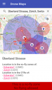
无人机和模型飞机的飞行员可以使用瑞士无人机地图来了解他们被允许飞行的地方。禁飞区和交通管制区域在地图上有专门的颜色,因此很容易看到。由于地图上直观的标记,机场和直升机场清晰可见。
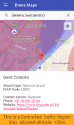
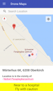
在较高的缩放级别下,地图会显示相关的附加信息,例如医院和山区机场。站点标记的选择不仅显示有关该地区的信息,还显示机场的电话号码和网站。该联系数据允许自发且轻松地申请特殊飞行许可证。
免责声明:我们不能保证 100% 的准确性或正确性,并拒绝承担任何及所有责任。这个应用程序是私人开发的。它基于来自政府和非政府来源的公开数据(有关详细信息,请参阅 https://opendata.swiss/de/organization/bundesamt-fur-zivilluftfahrt-bazl)。然而,开发商既没有任何法律权力,也不以任何方式隶属于瑞士政府(除了向其纳税)。
让我们重申最后一句话:也许连我们在谷歌的亲爱的朋友也会理解它。我们与瑞士政府没有任何隶属关系。
Swiss Drone Maps - 版本20.9
(20-03-2025)新特性Updated the data of flight obstacles to the newest version and format of BAZL (the swiss department of civilian air-traffic) and adapted the colors in the app to match the official ones more closely.
Swiss Drone Maps - APK信息
APK版本: 20.9程序包: ch.abwesend.dronemaps名称: Swiss Drone Maps大小: 9 MB下载次数: 33版本: 20.9发布日期: 2025-03-20 21:36:39最小屏幕: SMALL支持的CPU:
程序包ID: ch.abwesend.dronemapsSHA1签名: 67:89:21:2E:94:C1:A6:E2:44:29:F0:A6:D3:07:6E:38:18:2A:EB:D3开发商 (CN): Florian Gubler组织 (O): 2Gusoft本地 (L): Zurich国家/地区 (C): CH州/市 (ST): Zurich程序包ID: ch.abwesend.dronemapsSHA1签名: 67:89:21:2E:94:C1:A6:E2:44:29:F0:A6:D3:07:6E:38:18:2A:EB:D3开发商 (CN): Florian Gubler组织 (O): 2Gusoft本地 (L): Zurich国家/地区 (C): CH州/市 (ST): Zurich
Swiss Drone Maps的最新版本
20.9
20/3/202533 下载次数9 MB 大小
其他版本
20.1
1/1/202533 下载次数8.5 MB 大小
19.8
4/10/202433 下载次数8.5 MB 大小


同类应用


English


